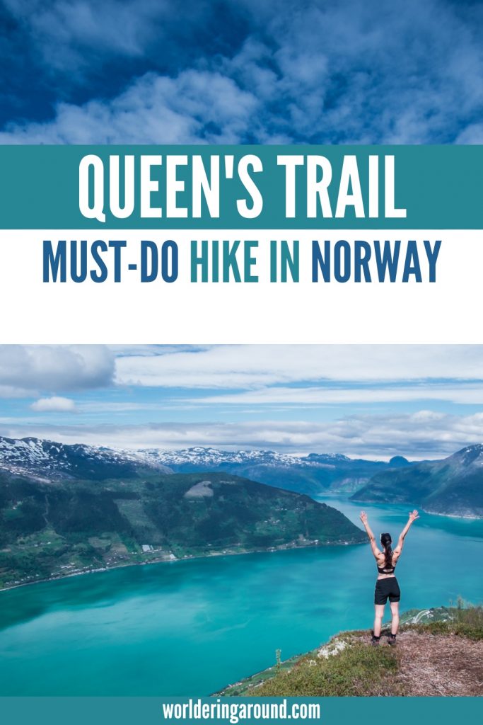
Dronningstien hike is a favorite trail of Norwegian Queen Sonja, hence named “Queen’s Trail”. Stunning views, varied terrain, and 360-degree views make this trail a great hike for everyone. Check all the details about the Dronningstien hike here.
Dronningstien is one of the most beautiful hikes in Norway. The views from it are so stunning, that even HM Queen Sonja of Norway chose it as one of her favorite trails in the Hardangerfjord region. The hike is located in the high mountains between Kinsarvik and Lofthus and offers spectacular fjord views.
The Queen’s Trail is less known by international travel groups than other famous hikes in Norway, such as Trolltunga, Kjeragbolten, or Romsdalseggen. This makes it more tranquil!
This post may contain affiliate links, which means that I may receive a small commission, at no cost to you, if you make a purchase through a link. More details here.

Dronningstien Hike – The Location
The Dronningstien trail lies between Kinsarvik and Lofthus in the Hardanger region of Norway.
The path is well marked, and on the top of the Hardangervidda plateau, there are blue letters “D” to guide you through the trail.


Dronningstien Hike – The Details
Total distance: 16km from Røte to Lofthus (3km more, if you walk from Kinsarvik to Røte.)
Total time: 6-7 hours
Highest point: 1100m
Elevation difference: around 900 m
Path: Marked path with red T, and then blue D.
Difficulty: Demanding (but not too exposed or strenuous in my opinion).
Season: Summer (June to October, depending on snow)
Starting point: Carpark at Røte (a road 3 km up from Kinsarvik)
Endpoint: Lofthus (it can be done the other way round too). You can take a bus or a shuttle back to the car.


Car park at Dronningstien
The car park in Røte costs 200 NOK (as of June 2022). You need to pay it before entering the last part of the road up, by cash or by Vipps (Norwegian money app).
If you want, you can also park the car by the ESSO petrol station in Kinsarvik, and then walk the first part of the road up. I would recommend this option since you still need to get your car back.
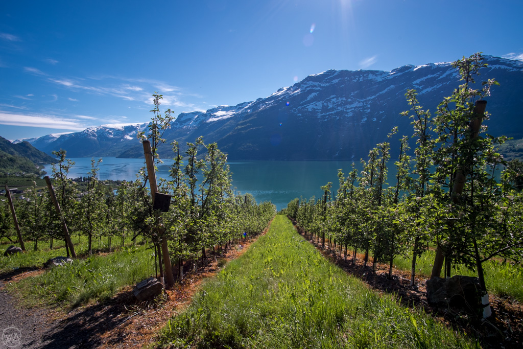
We started the hike from Kinsarvik, and we drove up to the car park at Røte. I liked walking in this direction for beautiful views and then descending in Lofthus to the path surrounded by apple trees. The taste of fresh apple juice after the long hike was amazing!
However, this meant we needed to pay 200 NOK for the car park at the beginning of the trail, and then still come back to get the car. We took a public bus from Lofthus to Kinsarvik for 40 NOK per person. However, the bus didn’t go up the hill to Røte, which meant that we needed to do another 3km up to get the car (two amazing girls from our group did that for us!).


How to get to Dronningstien Hiking Trail – Transport to Dronnigstien
By car
This is probably the easiest way of getting to the beginning of the trail.
If you start from Kinsarvik, then drive up the road from Esso Gas Station to Røte. The car park costs 200 NOK there. Or, leave your car by the petrol station and walk up.
If you start the hike from Lofthus, you can park near the harbor next to the Bunnpris (free).
By bus
There is a bus that goes between Lofthus and Kinsarvik – check the timetable here. The trip takes around 15 min and costs 40 NOK pp.
By shuttlebus
There is a shuttle bus that runs in the high season from Lofthus to the beginning of the Dronningstien hike at Røte and costs 165 NOK per person. Check more details here.


Dronningstien Hike Description
The hike is described as long and demanding with a steep descent towards Lofthus. Towards the end, I could feel my legs being tired.
My Strava app showed me a moving time of 4 hours and 20 minutes. In total, we took 6 hours and 50 minutes to complete the trail (with many photo stops).
Dronningstien Map
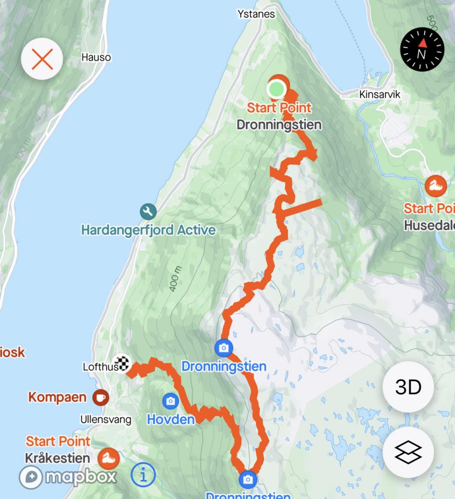
Stages of Dronningstien hiking trail
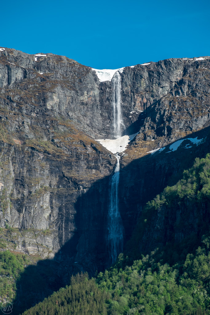
During the hike, you walk through forests, high mountains, and lush orchards.
The beginning of the hike is all going up along the gravel road. There are some occasional views on the way.
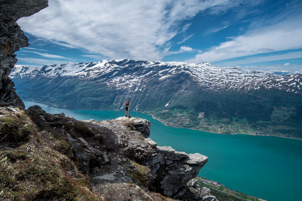
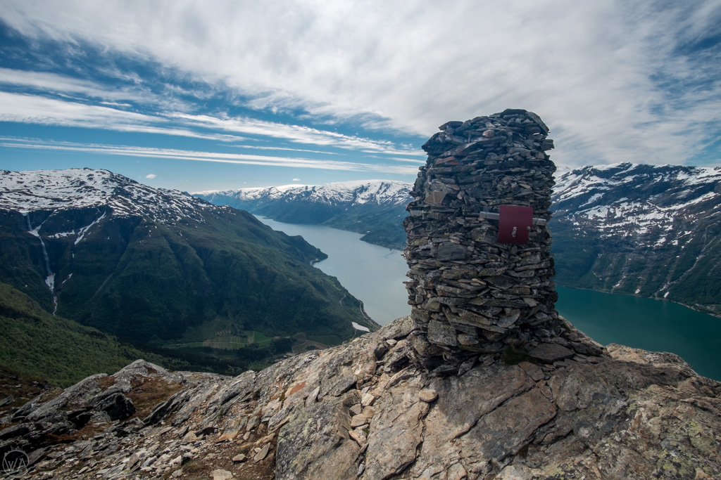
Once you reach the beginning of the high plateau and the sign of “Dronningstien” with HM Queen Sonja stone in front of it, the breathtaking views of Hardangerfjord start there. It doesn’t take long to realize why this hike is one of the Queen’s favorites.
On top of the plateau, there are some ups and downs but the terrain is relatively flat.
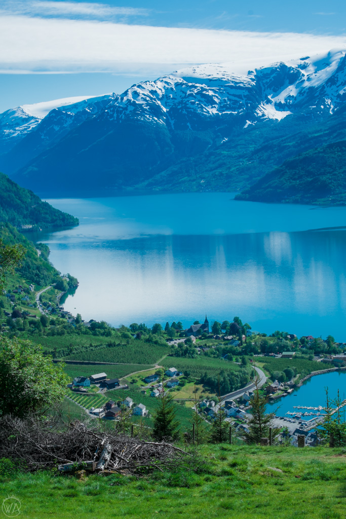
At all points, the views of Hardangerfjord are to the right. Along the way, you can admire the views of Kinsarvik, Lofthus, Hardangerfjord, and Edifjord.

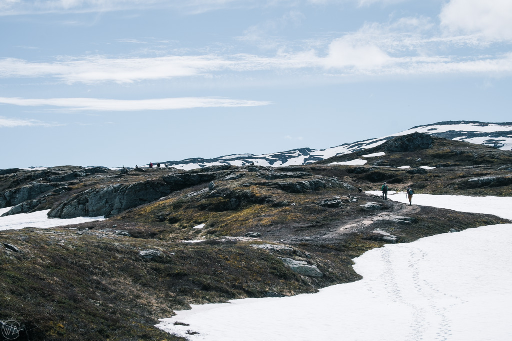

In June there was plenty of fresh water on the trail in the form of rivers.
The high point of a route is a cairn at 1110m with a box including a tour book you can sign.
From here, it is mostly descending back to Lofthus.


Queen’s Trail – Monk Steps
On the Lofthus side of the Queen’s Trail, you can find a big stone staircase with over 600 steps. These are the Munktrappene (Monk Steps), which were built by monks between the 13th and 16th centuries.
The descent is steep and winding. It eventually reaches tree coverage and then opens up to the view of Lofthus and fruit farms.
Don’t forget to buy a bottle of apple juice or cider from the local farm at the end of the hike. Along the trail, there are some self-serving fridges, where you just take what you want, and send money by Vipps (or cash into the box).


Where to stay near the Dronningstien hike?
There are several places for good Dronningstien hike accommodation in nearby villages. The towns are all very pretty, so you can be guaranteed to have amazing views. Some of the recommended places include guest houses, campsites, and hotels in Lofthus and Kinsarvik or Eidfjord:
- Hotel Ullensvang – this waterfront hotel in Lofthus, offers views of Folgefonna Glacier, indoor and outdoor pools, along with a private beach area. Check prices and availability here.
- Hardanger Hostel B&B – beautiful guesthouse in Lofthus. Check prices and availability here.
- Lofthus Camping – stunning views by the fjord, availability to rent cottages, park with campervan or camp. Check prices and availability here.
- Ullensvang Gjesteheim – Set on a farm in Lofthus, just 200 meters from the shores of Hardangerfjord, this property offers simple accommodation with free Wi-Fi. Check prices and availability here.
- Huse Gjestegard – located in Kinsarvik, it has a beautiful garden with fjord views. Check prices and availability here.
- Kinsarvik Camping – camping area, parking for motorhomes, and cabins for rent. Check prices and availability here.


Posted: 2022, Updated: 2024
Have you done a Dronningstien hike before? Would you like to do it? Let me know in the comments!
Read more about Norway:
30 Best Hikes In Norway Explained + Map
Tips on how to travel Norway on a budget
Best Norwegian gifts and souvenirs to bring back from your trip
Like it? Pin it!

We will be doing this hike in a matter of weeks. Here are my Qs:
-I am confused whether to park at the Esso station or Rote. Is it better to have the option to get the bus OR the shuttle from Lofthus and not have to walk 3km up the hill at the end? Or is the shuttle more reliable.
-Do you need to reserve the shuttle in advance or can you just pick it up when you are ready?
-How much is it to park at ESSO?
-Can we pay cash for both the parking and the shuttle or bus? We are not Norwegian and do not have VIPPS. -OR is Apple Pay accepted?
Thanks so much for your very thorough article. Appreciate any parking and transport info you can give me in advance of our hike!!!!
Best,
Bronna
– if you can, get the shuttle, for us the bus didn’t drive all the way back to the car park, so that wasn’t good
– I think it’s better to reserve in high season, but in general they should have spaces – check with them directly
– I don’t remember the price to park at Esso sadly, but if you find out, let everyone know here :)
Good luck with your hike and enjoy!
Hi. Which half has the prettier views – Lofthus or Kinsarvik? We’re probably only going to hike halfway through and then turn around — I just don’t want to mess with the shuttle and I have younger children and don’t want to commit to the full hike if they get tired after a few hours.
I think I’ve read 20 reviews of this hike but no one has ever said which side is visually better!
It’s probably subjective, but I preferred the views from Kinsarvik side, and that’s the direction I started the hike from. Good luck!